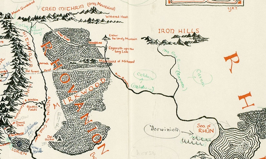
Image via Blackwell’s Rare Books
Back in April, we highlighted for you a trove of 110 illustrations by J.R.R. Tolkien, offering a rare glimpse of the author’s artistic talents. Tolkien didn’t just like to write books, as we saw. He also liked to draw illustrations for these books, which helped him to conceptualize the fantasy worlds he was creating.
Just this month, Houghton Mifflin released a new book called The Art of The Lord of the Rings by J.R.R. Tolkien, which brings together more than 180 drawings, inscriptions, maps, and plans–all drawn by Tolkien as part of his worldbuilding creative process. Most were never published until now.
And then we get this: a newly-discovered map annotated by Tolkien. Found in a copy of The Lord of the Rings that originally belonged to Pauline Baynes (the artist who illustrated Tolkien’s novels in print), the map intriguingly connects Tolkien’s fantasy world to real places on our globe. According to The Guardian, annotations on the map (click here to view the materials in a larger format) suggests that “Hobbiton is on the same latitude as Oxford [where Tolkien taught], and implies that the Italian city of Ravenna could be the inspiration behind the fictional city of Minas Tirith.” Belgrade, Cyprus, and Jerusalem also get listed as reference points. Discovered by Blackwell’s Rare Books, the rare map will be put on the market for an asking price of £60,000.
You can learn more about this map, considered “perhaps the finest piece of Tolkien ephemera to emerge in the last 20 years,” over at The Guardian.
Related Content:
110 Drawings and Paintings by J.R.R. Tolkien: Of Middle-Earth and Beyond
Discover J.R.R. Tolkien’s Personal Book Cover Designs for The Lord of the RingsTrilogy
The Only Drawing from Maurice Sendak’s Short-Lived Attempt to Illustrate The Hobbit
Hear J.R.R. Tolkien Read From The Lord of the Rings and The Hobbit
Soviet-Era Illustrations Of J. R. R. Tolkien’s The Hobbit (1976)


Leave a Reply