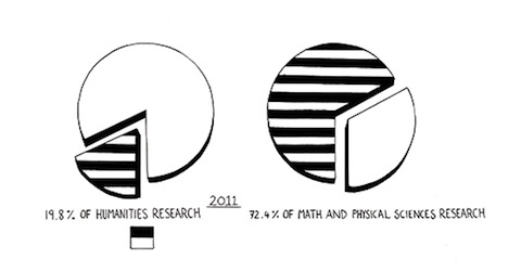
Humanists are feeling a bit beleaguered these days. And who can blame them? Enrollments in humanities courses are in steady decline nationwide, and everyone’s looking for a cause. Some blame the decline on the tough economy and the relentlessly vocational focus of students. Others attribute it to the “anti-intellectual moment” in which we’re now living. Still others place the blame right in the laps of humanists who have “lost faith in their own enterprise.” They’re committing their own form of career suicide. And then some fault the ever-increasing encroachment of science. For nowadays science tries to answer all questions, including what’s good, beautiful and true.
But if you listen to Steven Pinker, he’ll tell you that science is not the problem. Earlier today, the eminent Harvard psychologist published a piece in The New Republic called Science Is Not Your Enemy: An impassioned plea to neglected novelists, embattled professors, and tenure-less historians. And he offered these assurances:
[Science doesn’t have] an imperialistic drive to occupy the humanities; the promise of science is to enrich and diversify the intellectual tools of humanistic scholarship, not to obliterate them. And it is not the dogma that physical stuff is the only thing that exists. Scientists themselves are immersed in the ethereal medium of information, including the truths of mathematics, the logic of their theories, and the values that guide their enterprise. In this conception, science is of a piece with philosophy, reason, and Enlightenment humanism. It is distinguished by an explicit commitment to two ideals, and it is these that scientism seeks to export to the rest of intellectual life.
If you’re a humanist trying to figure out whether you can take comfort in Pinker’s argument, you can read the rest of his piece here.
Related Content:
Can Science Fiction Save the Liberal Arts? (Asks The New Republic)
Serial Entrepreneur Damon Horowitz Says “Quit Your Tech Job and Get a Ph.D. in the Humanities”
Read The Harvard Classics: A Free DIY Education in the Liberal Arts


