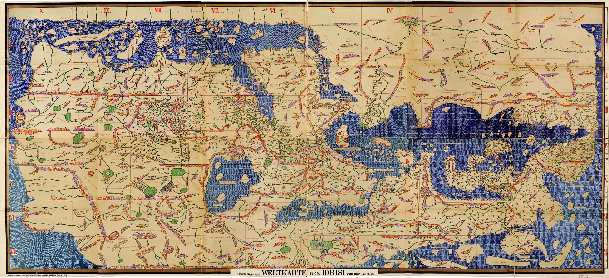
Cast your mind, if you will, to the city of Ceuta. If you’ve never heard of it, or can’t quite recall its location, you can easily find out by searching for it on your map application of choice. Back in the twelfth century, however, you might have had to consult an image of the known world engraved on a 300-pound, six-and-a-half-foot wide silver disk — but then, if you had access to that disk, you’d know full well where Ceuta was in the first place. For it belonged to King Roger II of Sicily, who’d commissioned it from the geographer, traveler, and scholar Abū Abdallāh Muhammad ibn Muhammad ibn Abdallāh ibn Idrīs al-sharif al-Idrīsī — more succinctly known as Muhammad al-Idrisi — perhaps Ceuta’s most accomplished son.
“Al-Idrisi studied in Cordoba and traveled widely as a young man, visiting Asia Minor, Hungary, the French Atlantic coast, and even as far north as York, England,” writes Big Think’s Frank Jacobs. In 1138, Roger II “invited al-Idrisi to his court at Palermo, possibly to explore whether he could install the Muslim nobleman as a puppet ruler in the bits of North Africa under his dominion, or in Spain, which he hoped to conquer.” The project that resulted from this meeting, fifteen years of work later, was “a new and accurate map of the world.” In addition to knowledge gained on his own extensive travels, Al-Isidiri consulted ancient sources like Ptolemy’s Geography and “interviewed ship’s crews and other seasoned travelers, but retained only those stories on which all were in agreement,” leaving out the mythical tribes and fantastical creatures.
In addition to the grand disk, Al-Idrisi created an atlas consisting of 70 detailed, annotated maps called Nuzhat al-mushtāq fi’khtirāq āl-āfāq. That Arabic title has been variously translated — “the book of pleasant journeys into faraway lands,” “the excursion of the one who yearns to penetrate the horizons,” “the excursion of one who is eager to traverse the regions of the world” — but in Latin, the book was simply called the Tabula Rogeriana. Alas, writes Jacobs, “the original Latin version of the atlas (and the silver disk) were destroyed in 1160 in the chaos of a coup against William the Wicked, Roger’s unpopular son and successor.” Still, Al-Idrisi did manage to bring the Arabic version back with him to North Africa, where it became an influential example of scientific cartography for the Islamic world.
A glance at the Library of Congress’ German facsimile from 1928 at the top of the post reveals that Al-Idrisi’s world map looks quite unlike the ones we know today. He put south, not north, at the top, the better for Islamic converts to orient themselves toward Mecca. “His Europe is sketchy, his Asia amorphous, and his Africa manages to be both partial and oversized,” Jacobs notes, but nevertheless, he got a lot right, including such little-known regions as the kingdom of Silla (located in modern-day Korea) and calculating — approximately, but still impressively — the circumference of the entire Earth. We might consider paying tribute to Al-Idrisi’s achievements by making a trip to his hometown (a Spanish-held city, for the record, at the very tip of Africa north-east of Morocco), which seems like a pleasant place to spend a few weeks — and a promising starting point from which to penetrate a few horizons of our own.
via Big Think
Related content:
How Did Cartographers Create World Maps before Airplanes and Satellites? An Introduction
40,000 Early Modern Maps Are Now Freely Available Online (Courtesy of the British Library)
500+ Beautiful Manuscripts from the Islamic World Now Digitized & Free to Download
The Birth and Rapid Rise of Islam, Animated (622‑1453)
Based in Seoul, Colin Marshall writes and broadcasts on cities, language, and culture. His projects include the Substack newsletter Books on Cities, the book The Stateless City: a Walk through 21st-Century Los Angeles and the video series The City in Cinema. Follow him on Twitter at @colinmarshall or on Facebook.

Why is the map upside down??
Islamic maps of that period are typically created with south “up”… north at the top didn’t really become “normal” until the 1800s. It’s not necessarily upside down.
The Bodleian Libray at Oxford also has an Arabic copy with color plates.
Idriss 1 is also the founder of the first Moroccan state in 789.
All maps were upside-down because during that period, the southern hemisphere hosted the advanced civilizations of the world.
You’ll notice significant map and intellectual property shifts after the Renaissance “more like an intellectual robery”.
I have often wondered how a person or persons not present at the time of a creative work considers themselves an expert when not present at the time of creation.
Rome & Greece knew about the importance of India. Alexander the Great marched from Greece to India in 323–327BC.
Strangely the map is all confused about the world — East of Europe.!!
Regards to All, Dr.S.K.Pachauri IAS Retd
Moorish, there were no advanced civilizations in the southern hemisphere at the time this map was made. Al Idrisi wasn’t committing intellectual theft when he used Ptolemys Geography or anyone else work in antiquity. Oh sorry, you were incenuating that intellectual work from the Renaissance was plagiarized or stolen from Arabic intellectual work. Actually the Arabs were continuing work from Roman, who were continuing work from Greeks. We should all be glad they kept building on eachother. If I was you I would study up on your history instead of regurgitating false “Woke” historical revisionism.