After John Ford, the history of U.S. expansion went by the name “How the West Was Won.” Decades earlier, in his essay “Annexation,” Jacksonian journalist John O’Sullivan famously coined the phrase “manifest destiny.” Historian Richard Slotkin called it “regeneration through violence” and novelist Cormac McCarthy summed up the jagged, ever-moving line of westward expansion from sea to sea with two words: Blood Meridian.
Indigenous versions of the story do not tend to enter common parlance in quite the same way, a fact upon which Vine Deloria, Jr. remarks in his “Indian Manifesto,” Custer Died for Your Sins. Violence is always central to the story. Usually the savagery of Native people is taken for granted. Savagery of settlers may be more or less emphasized. Yet the long history of land theft over the course of the centuries is also one of broken treaty after treaty.
Few tribes were defeated in war by the United States, but most sold some land and allowed the United States to hold the remainder in trust for them. In turn, the tribes acknowledged the sovereignty of the United States in preference to other possible sovereigns.
Caught between warring European empires, Indigenous nations made the best deals they could with the advancing U.S. and its army of Civil War veterans. “From this humble beginning the federal government stole some two billion acres of land and continues to take what it can without arousing the ire of the ignorant public.”
The brutality of the 19th century became professionalized, carried out by regulars in uniform, hence the detached language of “Indian wars.” These were followed by other kinds of violence: institutionalized paternalism, further encroachment and enclosure, and the forced removal of thousands of children from their parents and into reeducation camps.
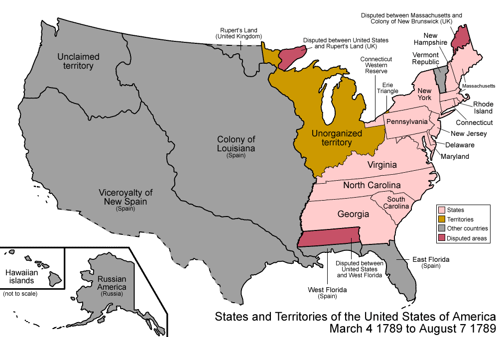
The two maps you see here, with sweepingly broad visual gestures in gif form, illustrate the 19th century seizure of land across the North American continent from the perspective of a U.S. national history and that of an Indigenous multi-national history. The map at the top traces the story from the country’s beginnings in the 13 colonies to the annexation, purchase, and finally statehood of Hawaii and Alaska in 1959.
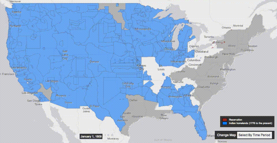
The above map is more focused, spanning the years 1810 to 1891. As Nick Routley points out in a post at Visual Capitalist, “five of the largest expansion events in U.S. history” took place during the 1800s, though the first one he cites falls outside the timeline above. The 1803 Louisiana Purchase ended up acquiring what now makes up “nearly 25% of the current territory of the United States, stretching from New Orleans all the way up to Montana and North Dakota.”
Other notable events include the 1819 purchase of Florida from Spain by John Quincy Adams, the aforementioned purchase of Alaska from Russia, and the 1845 annexation of Texas. The Mexican-American War of 1848 gets less mention these days, though it expanded slavery and was quite hotly debated at the time by such principled figures as Henry David Thoreau, who refused to pay his poll tax over it and wrote “Civil Disobedience” while in jail.
In the so-called Mexican Cession, Texas became a state and “the United States took control of a huge parcel of land that includes the present-day states of California, Nevada, and Utah, as well as portions of Arizona, Colorado, New Mexico, and Wyoming.” Mexico, on the other hand, “saw the size of their territory halved.” After each seizure of territory, mass migrations westward commenced in wave upon wave.
Routely does not survey these migration events, but you can learn about them in accounts like Roxanne Dunbar-Ortiz’s Indigenous People’s History of the United States and Deloria’s manifesto. When we approach the founding and expansion of the U.S. from multiple perspectives, both visual and historical, we understand why critical historians often use the phrase “settler colonialism” rather than “westward expansion” or its synonyms. And why the overused and limited phrase “nation of immigrants” might just as well be “nation of migrants.”
Related Content:
Native Lands: An Interactive Map Reveals the Indigenous Lands on Which Modern Nations Were Built
Josh Jones is a writer and musician based in Durham, NC. Follow him at @jdmagness
There are now a third animated map, which shows the expansion using towns and forts as reference, here: https://www.youtube.com/watch?v=fkvL1Muqv‑I